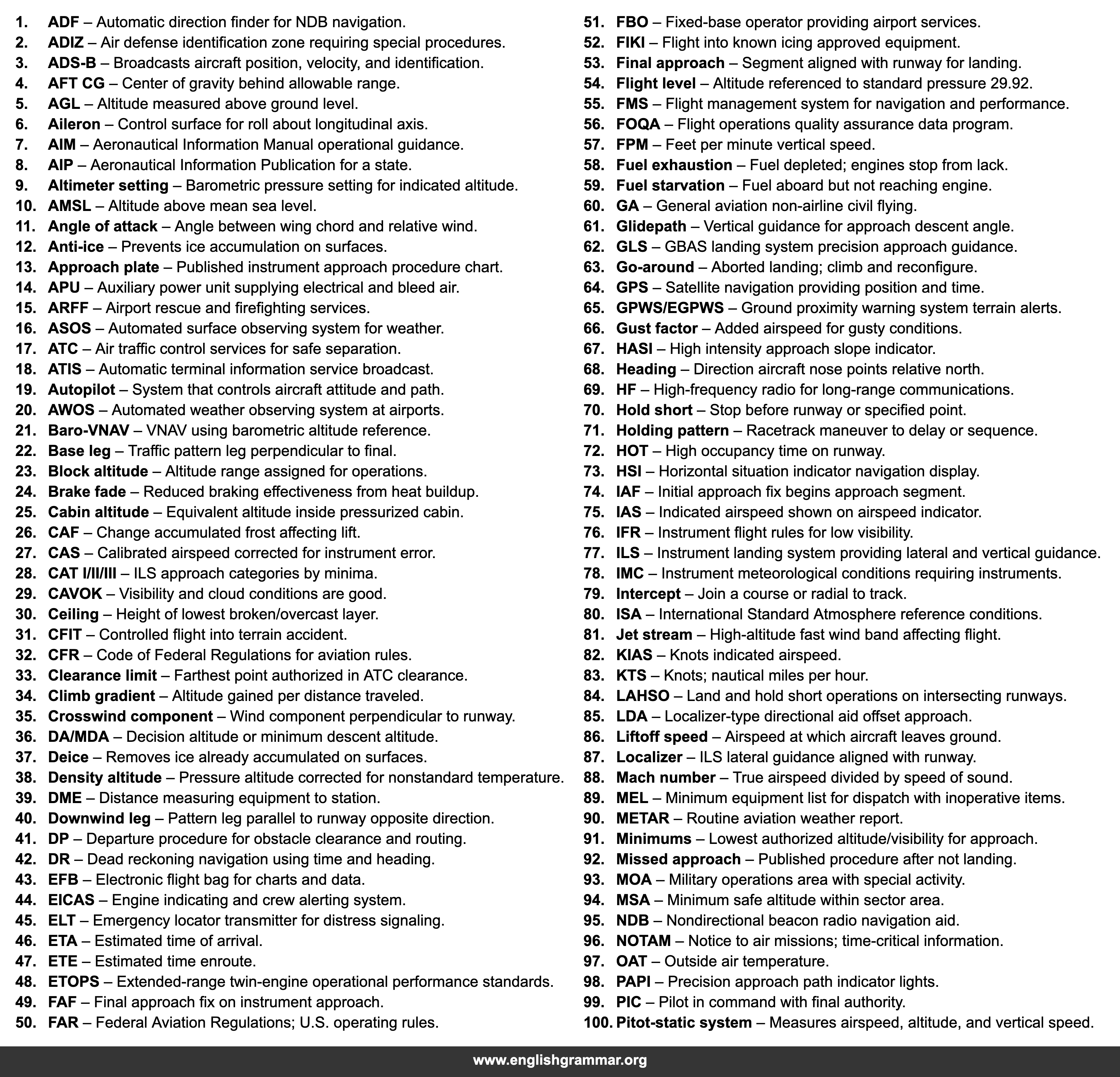
| No. | Term | Definition |
|---|---|---|
| 1. | ADF | Automatic direction finder for NDB navigation. |
| 2. | ADIZ | Air defense identification zone requiring special procedures. |
| 3. | ADS-B | Broadcasts aircraft position, velocity, and identification. |
| 4. | AFT CG | Center of gravity behind allowable range. |
| 5. | AGL | Altitude measured above ground level. |
| 6. | Aileron | Control surface for roll about longitudinal axis. |
| 7. | AIM | Aeronautical Information Manual operational guidance. |
| 8. | AIP | Aeronautical Information Publication for a state. |
| 9. | Altimeter setting | Barometric pressure setting for indicated altitude. |
| 10. | AMSL | Altitude above mean sea level. |
| 11. | Angle of attack | Angle between wing chord and relative wind. |
| 12. | Anti-ice | Prevents ice accumulation on surfaces. |
| 13. | Approach plate | Published instrument approach procedure chart. |
| 14. | APU | Auxiliary power unit supplying electrical and bleed air. |
| 15. | ARFF | Airport rescue and firefighting services. |
| 16. | ASOS | Automated surface observing system for weather. |
| 17. | ATC | Air traffic control services for safe separation. |
| 18. | ATIS | Automatic terminal information service broadcast. |
| 19. | Autopilot | System that controls aircraft attitude and path. |
| 20. | AWOS | Automated weather observing system at airports. |
| 21. | Baro-VNAV | VNAV using barometric altitude reference. |
| 22. | Base leg | Traffic pattern leg perpendicular to final. |
| 23. | Block altitude | Altitude range assigned for operations. |
| 24. | Brake fade | Reduced braking effectiveness from heat buildup. |
| 25. | Cabin altitude | Equivalent altitude inside pressurized cabin. |
| 26. | CAF | Change accumulated frost affecting lift. |
| 27. | CAS | Calibrated airspeed corrected for instrument error. |
| 28. | CAT I/II/III | ILS approach categories by minima. |
| 29. | CAVOK | Visibility and cloud conditions are good. |
| 30. | Ceiling | Height of lowest broken/overcast layer. |
| 31. | CFIT | Controlled flight into terrain accident. |
| 32. | CFR | Code of Federal Regulations for aviation rules. |
| 33. | Clearance limit | Farthest point authorized in ATC clearance. |
| 34. | Climb gradient | Altitude gained per distance traveled. |
| 35. | Crosswind component | Wind component perpendicular to runway. |
| 36. | DA/MDA | Decision altitude or minimum descent altitude. |
| 37. | Deice | Removes ice already accumulated on surfaces. |
| 38. | Density altitude | Pressure altitude corrected for nonstandard temperature. |
| 39. | DME | Distance measuring equipment to station. |
| 40. | Downwind leg | Pattern leg parallel to runway opposite direction. |
| 41. | DP | Departure procedure for obstacle clearance and routing. |
| 42. | DR | Dead reckoning navigation using time and heading. |
| 43. | EFB | Electronic flight bag for charts and data. |
| 44. | EICAS | Engine indicating and crew alerting system. |
| 45. | ELT | Emergency locator transmitter for distress signaling. |
| 46. | ETA | Estimated time of arrival. |
| 47. | ETE | Estimated time enroute. |
| 48. | ETOPS | Extended-range twin-engine operational performance standards. |
| 49. | FAF | Final approach fix on instrument approach. |
| 50. | FAR | Federal Aviation Regulations; U.S. operating rules. |
| 51. | FBO | Fixed-base operator providing airport services. |
| 52. | FIKI | Flight into known icing approved equipment. |
| 53. | Final approach | Segment aligned with runway for landing. |
| 54. | Flight level | Altitude referenced to standard pressure 29.92. |
| 55. | FMS | Flight management system for navigation and performance. |
| 56. | FOQA | Flight operations quality assurance data program. |
| 57. | FPM | Feet per minute vertical speed. |
| 58. | Fuel exhaustion | Fuel depleted; engines stop from lack. |
| 59. | Fuel starvation | Fuel aboard but not reaching engine. |
| 60. | GA | General aviation non-airline civil flying. |
| 61. | Glidepath | Vertical guidance for approach descent angle. |
| 62. | GLS | GBAS landing system precision approach guidance. |
| 63. | Go-around | Aborted landing; climb and reconfigure. |
| 64. | GPS | Satellite navigation providing position and time. |
| 65. | GPWS/EGPWS | Ground proximity warning system terrain alerts. |
| 66. | Gust factor | Added airspeed for gusty conditions. |
| 67. | HASI | High intensity approach slope indicator. |
| 68. | Heading | Direction aircraft nose points relative north. |
| 69. | HF | High-frequency radio for long-range communications. |
| 70. | Hold short | Stop before runway or specified point. |
| 71. | Holding pattern | Racetrack maneuver to delay or sequence. |
| 72. | HOT | High occupancy time on runway. |
| 73. | HSI | Horizontal situation indicator navigation display. |
| 74. | IAF | Initial approach fix begins approach segment. |
| 75. | IAS | Indicated airspeed shown on airspeed indicator. |
| 76. | IFR | Instrument flight rules for low visibility. |
| 77. | ILS | Instrument landing system providing lateral and vertical guidance. |
| 78. | IMC | Instrument meteorological conditions requiring instruments. |
| 79. | Intercept | Join a course or radial to track. |
| 80. | ISA | International Standard Atmosphere reference conditions. |
| 81. | Jet stream | High-altitude fast wind band affecting flight. |
| 82. | KIAS | Knots indicated airspeed. |
| 83. | KTS | Knots; nautical miles per hour. |
| 84. | LAHSO | Land and hold short operations on intersecting runways. |
| 85. | LDA | Localizer-type directional aid offset approach. |
| 86. | Liftoff speed | Airspeed at which aircraft leaves ground. |
| 87. | Localizer | ILS lateral guidance aligned with runway. |
| 88. | Mach number | True airspeed divided by speed of sound. |
| 89. | MEL | Minimum equipment list for dispatch with inoperative items. |
| 90. | METAR | Routine aviation weather report. |
| 91. | Minimums | Lowest authorized altitude/visibility for approach. |
| 92. | Missed approach | Published procedure after not landing. |
| 93. | MOA | Military operations area with special activity. |
| 94. | MSA | Minimum safe altitude within sector area. |
| 95. | NDB | Nondirectional beacon radio navigation aid. |
| 96. | NOTAM | Notice to air missions; time-critical information. |
| 97. | OAT | Outside air temperature. |
| 98. | PAPI | Precision approach path indicator lights. |
| 99. | PIC | Pilot in command with final authority. |
| 100. | Pitot-static system | Measures airspeed, altitude, and vertical speed. |
